East Palo Alto, California
| City of East Palo Alto | |
|---|---|
| — City — | |
| Nickname(s): EPA | |
 |
|
| Coordinates: | |
| Country | United States |
| State | California |
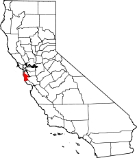
| County | San Mateo |
| Government | |
| - Mayor | Ruben Abrica |
| Area | |
| - Total | 2.6 sq mi (6.7 km2) |
| - Land | 2.5 sq mi (6.6 km2) |
| - Water | 0.04 sq mi (0.1 km2) |
| Elevation | 20 ft (6 m) |
| Population (2000) | |
| - Total | 30,506 |
| - Density | 12,585.5/sq mi (4,467.6/km2) |
| Time zone | PST (UTC-8) |
| - Summer (DST) | PDT (UTC-7) |
| ZIP code | 94303 |
| Area code(s) | 650 |
| FIPS code | 06-20956 |
| GNIS feature ID | 1658461 |
| Website | http://www.ci.east-palo-alto.ca.us |
East Palo Alto (often abbreviated EPA) is a city in San Mateo County, California, United States.
Contents |
Overview
As of the 2000 census, the population of East Palo Alto was 29,506 (31,915: 2003 estimate). It is situated on the San Francisco Peninsula, roughly halfway between the cities of San Francisco and San Jose. East Palo Alto is divided into 4 Specific Neighborhoods, despite being only 2.6 square miles. These areas are known as Midtown, Palo Alto Gardens, University Village, and Flood Park Estates.To the east is the San Francisco Bay, and to the west the prosperous city of Palo Alto. While widely assumed to be part of the city of Palo Alto[1][2], East Palo Alto has always been a separate entity, being located in a different county since its founding as an unincorporated community (Palo Alto is in Santa Clara County) and until recently having an entirely different demographic makeup. The two cities are separated only by San Francisquito Creek. The revitalization projects in 2000, and the surge of high income hi-tech professionals moving into the new developments (including employees from Google and Facebook), has begun to eliminate the cultural and economic differences between the two cities[3]. East Palo Alto and Palo Alto share both telephone area codes and postal ZIP codes.
Although about half of East Palo Alto's residents were African Americans in 1990, Latinos now constitute about 70% of the total population, while the proportion of African Americans has decreased to about 25%. A small minority of Pacific Islander population also resides in East Palo Alto, mostly Tongans with some Samoans and Fijians . East Palo Alto has the largest concentration of Pacific Islanders of any U.S. city or town outside of Hawaii.
In the past, East Palo Alto had experienced crime and poverty, especially during the 1980s and early 1990s. In 1992, the city once had the highest per-capita murder rate in the country with 24,322 people, and 42 murders, equaling a rate of 172.7 murders per 100,000 residents.[4]. Since then the city's crime problems have subsided, and the murder rate in particular has declined to a typical urban level. In 2006, East Palo Alto experienced a comparatively low 6 murders. There were 7 murders in 2007, and only 5 in 2008. According to a 2008 report provided by Ron Davis, Chief of Police, violence is on the decline. Davis reports an overall 42% reduction in homicides and a 20% reduction in overall crime between 2006–2008, compared to the previous three years.
The prosperity that benefited the Silicon Valley during the dot-com boom of the late 1990s largely bypassed East Palo Alto. The Ravenswood City School District, which serves East Palo Alto and part of adjoining Menlo Park, has struggled with low academic performance. Eventually, however, the Peninsula's shortage of land and soaring property prices meant that even East Palo Alto became an option for urban regeneration. Until recently, gentrification has been rare in East Palo Alto. East Palo Alto was depicted in the 1995 film Dangerous Minds, which was based on the experiences of a Carlmont High School teacher and her experiences with bussed in students from East Palo Alto.
East Palo Alto also includes a small piece of land across the Bayshore Freeway (US 101) from the shopping center, a roughly triangular area between US 101 and the San Francisquito Creek, which includes a former two-block-long retail business district known as Whiskey Gulch. (The name dates back to the time that Stanford University, in Palo Alto to the west, was dry and prohibited alcohol sales within a radius of one mile (1.6 km) from the campus: Whiskey Gulch was just outside the limits, and was home to a number of liquor stores and bars.) The city has torn down Whiskey Gulch and replaced it with the University Circle office complex.[5] A 200-room Four Seasons hotel opened in University Circle in 2006.
Over 25% of East Palo Alto (400+ acres) has been bulldozed and replaced with brand new housing and brandname retail establishments over the last 10–15 years[6], including IKEA, Sports Authority, Home Depot, Nordstrom, Togo's, Starbucks, Office Depot, Mi Pueblo Grocery, and Best Buy, attracting an entirely new demographic[7]. University Square community has become especially attractive to young hi-tech professionals and high-income couples, including many employees from Google, Facebook, Sun Microsystems, and various other software and startup companies.[8][9].
History
The Ohlone tribe of Native Americans inhabited this area at least by 1500 to 1000 BC. One tumulus was discovered in 1951 during development of the University Village subdivision near today's Costaño School. After a year-long excavation of 60 graves and 3000 artifacts, researchers concluded Native Americans had utilized the area as a cemetery and camp, rather than as a permanent settlement. In later years another mound was found near Willow Road and the railroad right-of-way.[10]
From the 1850s through the 1940s, East Palo Alto went through many changes. In 1849, Isaiah Woods attempted to make East Palo Alto a major shipping town and named the city Ravenswood. In 1868, after Woods investments failed he sold the wharf to Lester Cooley who built a brick factory. When the brick factory closed down it reverted to a simple farming community.
With the onslaught of WW I the north side of East Palo Alto became a military training ground with only the V.A. hospital in Menlo Park still existent. In the 1940s East Palo Alto was a farming community with many Japanese residents. During the war the Japanese were forced to internment camps and they lost their land, belongings, livelihoods and dreams. After the war many African-American families were diverted to EPA and during the civil rights movement of the 1960s there was a cultural re-awakening. The city was almost renamed Nairobi in 1968 to reflect its population's African roots.[11][12]
Significant gentrification occurred in East Palo Alto from around 2000, with the construction of a large shopping center named Ravenswood 101 (including a Home Depot, a Best Buy, and an IKEA store) and several upscale housing communities (intended for high-earning Silicon Valley workers). This gentrification has faced opposition from local residents. Some residents charge that it serves to price locals out of one of the region's only affordable communities while providing only low-paying jobs in the retail developments and consuming a disproportionate amount of the tiny city's land area (2.2 square miles).
In 2008, after 20 years without a supermarket, East Palo Alto individuals and organizations joined together to establish the East Palo Alto Community Farmers' Market.[13] In November 2009, the Mi Pueblo Food Center grocery store was added to the Ravenswood 101 shopping center in place of the former Circuit City store. The opening of Mi Pueblo store in East Palo Alto was the city's first full-service supermarket in 23 years.[14] Mi Pueblo operates more than a dozen markets in California, including one located in Mountain View. Although there are several local, small grocery stores in East Palo Alto, the establishment of Mi Pueblo Food Center in East Palo Alto marked a landmark in history for the city, as residents no longer have to drive to other cities to buy their groceries from a full-service supermarket.
During the most recent economic crisis of 2008-2009, the city has been divided by a large real-estate investor, Page Mill Properties, which has purchased almost the entire west side of East Palo Alto and contested most of the City's Rent Control laws in what many have claimed is a predatory equity scheme.
Incorporation
East Palo Alto has historically been at an economic disadvantage from its neighboring cities because of its limited tax base. While there is plentiful shopping and business outside East Palo Alto, there was relatively little inside East Palo Alto. Most of EPA was unincorporated county land so it was not eligible for many of the revenue benefits of being a city. Until 1983, East Palo Alto existed as an unincorporated "island" in San Mateo County, dependent on county government for services and on the San Mateo County Sheriff for police protection. After several years of pro-incorporation campaigning by local community groups, a 1982 ballot measure that was stopped by a lawsuit, and a subsequent election the next year, East Palo Alto became a city in June 1983. (Because of subsequent legal challenges to the last ballot measure, it wasn't until 1987 that the city was officially recognized as such. The legal challenges were led by former U.S. Congressman Pete McCloskey, who represented one of the real-estate brokers whose original blockbusting campaign had turned EPA into a mostly-black ghetto. The final tally was 1,777 for and 1,764 against, a margin of 13 votes; a majority of 50.2%.[15]
Geography
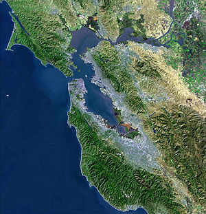
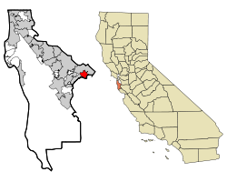
East Palo Alto is located in San Mateo County, its geographical coordinates are (37.467038, -122.139699)[16]. Despite its name, East Palo Alto lies almost entirely north, and not east, of Palo Alto. It is bordered on the west by Menlo Park and Palo Alto, and to the east by the San Francisco Bay. The San Francisquito Creek defines its western edge. To the north are Ravenswood Point and the western end of the Dumbarton Bridge in Menlo Park.
According to the United States Census Bureau, the city has a total area of 2.6 square miles (6.7 km²), of which 2.5 square miles (6.6 km²) are land and 0.04 square miles (0.1 km²) of it (0.78%) are water.
Demographics
As of the census[17] of 2008, there were 33,575 people, 6,648 households, and 5,074 families residing in the city. The population density was 12,585.5 inhabitants per square mile (4,859.3 /km2). There were 7,573 housing units at an average density of 3,784.3/sq mi (2,073.7/km²). The racial makeup of the city was 6.1% White, 23.5% African American, 0.73% Native American, 4.1% Asian, 11.8% Pacific Islander (mainly Tongan and Samoan immigrants), 11.8% from other races, and 1.2% from two or more races. Hispanic or Latino of any race were 74.3% of the population.
There were 6,648 households out of which 45.3% had children under the age of 18 living with them, 47.2% were married couples living together, 16.8% had a female householder with no husband present, and 25.4% were non-families. 19.2% of all households were made up of individuals and 5.5% had someone living alone who was 65 years of age or older. The average household size was 5.20 and the average family size was 5.64.
In the city the population was spread out with 38.0% under the age of 18, 15.4% from 18 to 24, 33.6% from 25 to 44, 14.0% from 45 to 64, and 4.1% who were 65 years of age or older. The median age was 24 years. For every 100 females there were 109.2 males. For every 100 females age 18 and over, there were 108.9 males.
The median income for a household in the city was $45,006, and the median income for a family was $43,342. Males had a median income of $25,631 versus $28,044 for females. The per capita income for the city was $14,774. About 17.5% of families and 19.2% of the population were below the poverty line, including 18.6% of those under age 18 and 11.9% of those age 65 or over.
Transportation
East Palo Alto is bisected by U.S. Route 101, a freeway with exits serving the city and frontage roads on either side. The Dumbarton Bridge connects East Palo Alto to Alameda County, which lies to the east across San Francisco Bay, and carries State Route 84 into East Palo Alto toward U.S. 101.
Education
Primary and secondary schools
The Ravenswood City School District has its headquarters in East Palo Alto.[18]
District K-8 schools include Costaño Elementary School,[19] Belle Haven Community School,[20] and James Flood Magnet School.[21] 5-8 schools include Cesar Chávez Academy and Ronald McNair Academy.[22][23] San Francisco 49ers Academy, a 6-8 district school, is in Palo Alto.[24] K-4 schools in East Palo Alto include Edison Brentwood Academy (a district charter) and Green Oaks Academy.[25][26] Ravenswood Child Development Center is in East Palo Alto.[27]
Sequoia Union High School District operates the zoned high schools in the area. Some residents are zoned to Carlmont High School in Belmont, some residents are zoned to Menlo-Atherton High School in Atherton, and some residents are zoned to Woodside High School in Woodside.[28]
Public libraries
San Mateo County Library operates the East Palo Alto Library, located at East Palo Alto Library 2415 University Avenue East Palo Alto, CA 94303. The telephone number is 650.321.7712 [29]
Environment
The local area around the Dumbarton Bridge is an important ecological area, hosting many species of birds, fish and mammals. The endangered species California clapper rail is known to be present in the western bridge terminus area.
The bridge is not a significant source of noise affecting East Palo Alto; however, the city is affected by noise from events at the nearby Shoreline Amphitheatre in Mountain View.
Culture
East Palo Alto is also the home to several rappers. These rappers include Sean T, The Youngen, Chunk, Bigg Rigg, Band-Aide, Scoot Dogg, Ad Kapone, and Mac-10. Rapper Band-Aide of the Hoodstarz was arrested as of March 7, 2009 in a large-scale attempt to dismantle a East Palo Alto based gang known as the Taliban.[30] The raid to dismantle the Taliban consisted of more than 500 FBI agents and Bay Area Police.[31]
East Palo Alto is the home of the Major Taylor Cycling Club, named after the famous African-American bicycle racer "Major" Marshall Taylor.
Also, the city is home to the former UFC fighter, Eugene "The Wolf" Jackson.
References
- ↑ "The History of East Palo Alto". EPA.net website. January 22, 2007. http://www.epa.net/info/epa_history.html.
- ↑ "City of East Palo Alto 2005 Urban Water Management Plan" (PDF). City of East Palo Alto. January 3, 2006. pp. page 14. http://www.ci.east-palo-alto.ca.us/publicworks/EastPaloAlto2005UWMPFinalComplete.pdf.
- ↑ "Economic Development In East Palo Alto". EPA.net website. http://www.ci.east-palo-alto.ca.us/economicdev/successes.html.
- ↑ "East Palo Alto regarded as 'drug haven'". The Stanford Daily. January 30, 2002. http://www.stanforddaily.com/tempo?page=content&id=7291&repository=0001_article.
- ↑ Environmental Impact Report for the University Circle Redevelopment Plan, Report EMI7770, City of East Palo Alto
- ↑ "Economic Development In East Palo Alto". EPA.net website. http://www.ci.east-palo-alto.ca.us/economicdev/successes.html.
- ↑ "Community Living: How safe is East Palo Alto?". EPA.net website. http://www.epa.net/launch/epabboard/message?message_id=558044&forum_id=68219.
- ↑ "East Palo Alto Demographics". Zillow.com website. http://www.zillow.com/local-info/CA-East-Palo-Alto-people/r_11228/.
- ↑ "Roommates". Craigslist website. http://sfbay.craigslist.org/.
- ↑ Native American History of East Palo Alto
- ↑ [1]
- ↑ Acceptable Use - The History of East Palo Alto
- ↑ http://www.paloaltoonline.com/weekly/story.php?story_id=8272
- ↑ Mi Pueblo Food Center: Community
- ↑ "The History of East Palo Alto". EPA Acceptable Use. http://www.epa.net/info/epa_history.html.
- ↑ "US Gazetteer files: 2000 and 1990". United States Census Bureau. 2005-05-03. http://www.census.gov/geo/www/gazetteer/gazette.html. Retrieved 2008-01-31.
- ↑ "American FactFinder". United States Census Bureau. http://factfinder.census.gov. Retrieved 2008-01-31.
- ↑ "Welcome to the Ravenswood City School District." Ravenswood City School District. Retrieved on October 6, 2009.
- ↑ "Costaño Elementary." Ravenswood City School District. Retrieved on October 6, 2009.
- ↑ "Belle Haven Community School." Ravenswood City School District. Retrieved on June 23, 2010.
- ↑ "James Flood Magnet School." Ravenswood City School District. Retrieved on October 6, 2009.
- ↑ "Cesar Chávez Academy." Ravenswood City School District. Retrieved on October 6, 2009.
- ↑ "Ronald McNair Academy." Ravenswood City School District. Retrieved on October 6, 2009.
- ↑ "San Francisco 49ers Academy." Ravenswood City School District. Retrieved on October 6, 2009.
- ↑ "Schools." Ravenswood City School District. Retrieved on October 6, 2009.
- ↑ "Green Oaks Academy." Ravenswood City School District. Retrieved on October 6, 2009.
- ↑ "Ravenswood Child Development Center." Ravenswood City School District. Retrieved on October 6, 2009.
- ↑ "Boundary Search." Sequoia Union High School District. Retrieved on October 6, 2009.
- ↑ "East Palo Alto Library." San Mateo County Library. Retrieved on October 6, 2009.
- ↑ [2]
- ↑ Band-Aide of Dem HoodStarz Arrested
External links
- East Palo Alto Public Library - a branch of the San Mateo County Library
- A History of East Palo Alto
- EPA.net East Palo Alto web portal
- East Palo Alto News Paper
- East Palo Alto City Council website
- East Palo Alto Tenant's Rights Info (concerning rent control)
- Collective Roots - East Palo Alto organization promoting food system awareness and change
- East Palo Alto Community Farmers' Market - Community-based Certified Farmers' Market
|
||||||||||||||||||||
|
|||||||||||||||||||||||||